Category Archives: Travel

New Zealand Day 3 – 01/20/2018

New Zealand Day 3 01/20/2018 Photo Album

Saturday January 20, 2018 evolved into a spectacular summer day in the northern part of the South Island of New Zealand. John, Brenda, Jane and I once again visited Elaine’s Cafe across from the Alpine Lodge for a light breakfast. I could not get enough of the loose leaf fresh brewed tea. After breakfast we returned to our rooms and packed our bags and departed for Motueka, a small city along the Tasman Sea.

John drove the large Hyandai minivan while I navigated. We chose the route that followed the scenic Ruby Coast from Richmond to Motueka, and we stopped at Mapua and the Wharf District along the way. A short walk delivered us to some shops, where we browsed for a bit, and Jane purchased a bicycle trinket, that she plans to use as a zipper pull. The craft shop displayed a variety of metalworking art crafted from recycled odds and ends such as the locking lever on a bicycle tire hub that replicated the beak of a bird.

The Wharf in Mapua

The Golden Bear Brewpub in Mapua

Next we visited the dock that borders the inlet, and we were spectators to local kids, as they leaped into the rapidly moving incoming tide. The drop was roughly ten feet, but the young residents seemed immune to fear. From my position on the wharf I spotted the Golden Bear Brew Pub, so we wandered up to the counter and ordered lunch and beverages. Jane and I savored tacos and quenched our thirst with lemonade (7Up in New Zealand), while John sipped a lager. Brenda wandered over to the Smokehouse Cafe and picked up fish and chips and then joined us on the patio at the Golden Bear.

We Were Impressed by the Flower Wall at the Equestrian Motor Lodge

We vacated Mapua after lunch and continued a few additional kilometers to the Equestrian Motor Lodge in Motueka by 1:30PM. Allan, the owner/manager, checked us in by 2PM, and then I embarked on a forty minute run on the Intercoastal Walkway. Jane and Brenda overlapped with a shortened version in the form of a walk. The air temperature hovered at 29 C, which is quite warm, but it felt good compared to the winter temperatures we left behind in Colorado.

After our activities we drove to the New World Market and picked up breakfast and lunch goodies. Happy hour on the lawn outside our hotel was followed by dinner at Armadillos on High Street in Motueka. We looked forward to four nights and three more days in Motueka.

New Zealand Day 2 (Travers River) – 01/19/2018

Time: 11:30AM – 1:30PM

Location: Travers River above Lake Rotoiti

New Zealand Day 2 (Travers River) 01/19/2018 Photo Album

After a solid night’s rest in our new surroundings in St. Arnaud, New Zealand, Jane and I completed a walk to the car park on Lake Rotoiti. Steady overnight rain created lingering  low hanging clouds over the mountains surrounding the lake, and a large collection of puddles next to the car park provided new territory for the local ducks to explore. It was quite chilly in the early morning aftermath of the rainstorm, but we put our energy to productive use by reviewing a large sign with a map of the area. The billboard map highlighted several interesting tracks (hiking trails) in Nelson Lakes National Park near Lake Rotoiti. We also inspected the rates posted for the water taxi that departed from the dock near the car park.

Lake Rotoiti on Friday, January 19

On the way back to the lodge we stopped at Elaine’s Cafe across from the Alpine Lodge for breakfast. I devoured an apricot coffee cake along with a small cup of yogurt and washed it down with two delicious cups of English breakfast fresh brewed tea. New Zealand breakfasts were fast becoming a favorite.

After breakfast John, Brenda, Jane and I walked to the Nelson Lakes National Park Visitor Center. A very helpful young lady advised us on various hiking (tramping) options, and after much debate we settled on crossing the lake on the water taxi to the inlet and the Lakehead Hut. Instead of paying for a return ride on the boat, we elected to tramp along the Lake Shore Track. John purchased a fishing license from the man in the visitor center, and once the transaction was complete, I peppered the park ranger with questions about fly fishing in the area and more specifically the Travers River. He informed me that we needed a backcountry permit to fish the Travers River, and I could obtain one for free at the park office I was standing in.

We Returned for a Water Taxi Ride

Because of the recent heavy rain and the swollen nature of the streams that we crossed on our drive from Nelson to St. Arnaud, I was skeptical of the condition of the Travers River. The gentleman was persistent, however, and suggested that I should take my fishing gear and cast in the lake at the inlet of the Travers. He also mentioned that I was free to fish the river above the inlet for a stretch, before I reached the point where a trail crossed. Angling above the trail crossing required the backcountry permit that he alluded to earlier. His powers of persuasion were effective, and I resolved to wear my wet wading clothes and carry my fly fishing gear.

Creating a Wake

The four of us returned to the Alpine Lodge with a road map for the day, and I prepared to include some fishing time. We prepared lunches and reviewed our checklist of necessary hiking essentials, and then we returned to the car park and boarded the 10:30 water taxi. I struck up a conversation with a Swiss gentleman, who was also a passenger on the water taxi, since I noticed he carried a fly rod, fanny pack and net. He planned to fish upstream from the trail crossing, so I concluded we would not interfere with each other.

My Loves on Both Sides

I wore my hiking boots and hiking socks, but once we disembarked, I switched to wading socks and wading boots. After I assembled my Sage One five weight and strung my rod, Jane was kind enough to carry the rod case, hiking boots, and socks back to the Lakehead Hut to stash, while I fished. We agreed to meet back at the hut at 1:30, and this allotted me two hours to explore the Travers River and Lake Rotoiti. I was about to embark on my first New Zealand fishing adventure!

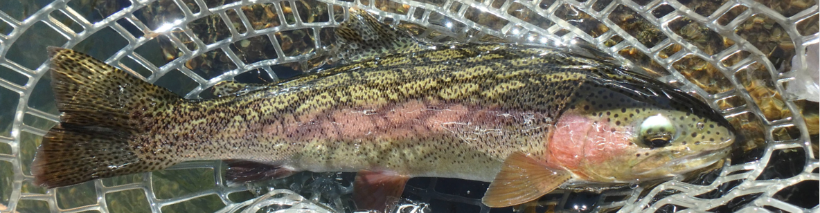
We snapped some photos with the spectacular backdrop of the Travers River valley, and then we said our goodbyes, and I followed a worn trail that angled across some tall brown grass to the river. The high temperature peaked at 75 F, but large clouds blocked the sun from time to time. To this uninitiated New Zealand fisherman, the conditions seemed nearly ideal. But what about the water level?

It did not take long to make the pleasant discovery that the river was crystal clear, but running higher than normal. Actually since I never fished here previously, I was not knowledgeable regarding normal, but most of the channel was covered, and the runs and riffles seemed to rush along at a fairly high velocity. I cautiously ambled back toward the lake in an effort to spot fish. My sources in the US who fished in New Zealand told me this was the key to success, and all the articles that I absorbed proposed the same sort of approach.

High and Clear After Substantial Rain

After what seemed like twenty minutes of futile fish spotting, I crossed a braid and began fishing upstream in the main channel. I only had two hours available, and I could no longer restrain myself from making some casts. I started my pursuit with a size ten Chernobyl ant, and after I covered a reasonable distance with no success, an older gentleman appeared, and he slowly approached me from the right bank. He informed me that a guide named Hannah and her client recently worked up the left side of the river, and he suggested that I cover the myriad of braids on the right. He seemed quite knowledgeable, and after more conversation I discovered why he made this impression. He was an agent with the Department of Conservation, and he asked to check my fishing license! I extracted it from my backpack, and he wrote my name and number in a small log book. My annual license was reviewed within my first hour of fishing in New Zealand!

Lots of Braided Areas

Once this official matter concluded, he advised me that I could fish up to a post along the left bank without a permit, and he pointed it out from our position downstream. I was relieved to hear this, as I was harboring some doubts that the man at the park office misinformed me. The DOC officer then kindly went above and beyond and implied that I should sample a nice pool a bit beyond the post. He casually commented, “I already checked your license, and I am walking the other way.” He even inspected my fly and offered that it should work, and then he went on to mention, that he spotted a couple very nice fish, as he walked the bank and warned me not to overlook shallow spots.

My optimism soared as he departed, and I worked my way through the braided area with elevated concentration. In spite of some long expert casts and superb drag free drifts, I never saw a fish in the quality braided section. I continued to some nice pools above a deadfall in the permit area since my friend promised to look the other way, but I could not spot a fish nor could I entice one to the surface with my foam ant. Next I reversed my direction and hiked downstream toward the lake, until I was beyond my initial starting point.

I added a salvation nymph dropper to my set up for the last thirty minutes, but this move was also to no avail. At 1:15PM I stumbled in some shallow water next to the bank and fell forward and completely soaked my slacks, shirt and front pack. Fortunately I was wading wet, and the air temperature was comfortable. With this embarrassing pratfall behind me, I returned to the hut and met Brenda and Jane.

After a brief snack the three of us hiked for three hours and thirty minutes along the lake on a intermittently muddy trail including quite a few dicey small stream crossings. I changed back into my hiking boots for this section of our adventure, but near the beginning both feet slid sideways on a pair of angled roots, and I once again greeted the earth with a thud. I now displayed a large bruise on my shin and created a severe bend in my trekking pole/wading staff.

As we moved along we noted many trees that displayed a dark black bark, and in many cases the bark attracted a significant quantity of wasps. The same trees also presented small yellow rectangular boxes or pink or yellow plastic triangles. Later on our trip I asked my fishing guide what these observations were all about. The explanation is quite interesting. The black bark is called sooty mould, and it exists on beech trees. Scale insects reside in the tree bark and suck sap and excrete a honeydew substance. The sooty mold fungi grow on the waste honeydew that runs down the trunk of the tree. The honeydew is a source of food for many native New Zealand birds, but it is also popular with non-native European wasps. New Zealand wildlife officials are concerned that the depletion of honeydew may affect the native bird population, so the yellow box and triangles are traps aimed at reducing the wasp colonies. It is amazing how a few observations lead to a new realm of knowledge.

This Area Was Very Green

Eventually after a steamy return hike through the rainforest, we returned to the car park and then the Alpine Lodge. For dinner on Friday Jane and I chose to cross the street to a takeaway (takeout) fish and chips establishment. Our food arrived wrapped in several layers of newspaper, and heat radiated from the newsprint surface. We carried our meals to an outdoor patio table by our room. Jane opened her packet first, and initially she assumed that the chips were in one bundle, and the fish were in the other. Eventually we determined that the fish was buried underneath a thick layer of french fries. The meal was quite good, but we concluded that one scoop of fries exceeded our stomach capacity.

Fish Landed: 0

New Zealand Day 1 – 01/18/2018

New Zealand Day 1 01/18/2018 Photo Album

Ever since I began fly fishing in my early thirties I dreamed of traveling to New Zealand, and on January 16, 2018 Jane and I made our dream a reality, as we stepped on to an American Airlines flight at Denver International Airport. We departed at 1PM and landed in Los Angeles LAX a few hours later. At LAX we found gate 41, where our American Airlines flight 83 departed at 11PM for Auckland, NZ. The reality of our next three weeks had not penetrated our beings at this time.

The flight from LAX to Auckland was uneventful, yet it would be an overstatement to describe it as fun or comfortable. Twelve and a half hours in a cramped coach seat is taxing regardless of how hard one tries to soften the experience. Jane and I bought neck cushions, and Jane sewed sleeping goggles, and we both took some over the counter drugs to induce sleep, but slumbering while sitting nearly upright with no leg room is not natural. I cannot imagine being a taller person in these circumstances.

Somehow we coped and touched down in Auckland at 9:30 on Thursday, January 18. The time difference of Auckland compared to Los Angeles is twenty-one hours, and our flight time was twelve hours. We actually skipped January 17 in our effort to reach New Zealand. Upon our arrival at the Auckland Airport we waited an hour for our luggage to appear, and another hour transpired while we passed through customs. Based on reports from other New Zealand fishing travelers; I scrubbed my waders, wading boots, and net thoroughly, but the customs check turned out to be a nonevent.

Next we navigated ourselves and our luggage to the Air New Zealand domestic terminal for our flight to Nelson on the northern end of the south island. We decided to eat lunch while we waited for our flight, and I ordered a BAP and a yogurt parfait. The BAP turned out to be similar to a breakfast sandwich. Another item to be removed from our checklist was purchasing Skinny mobile SIM cards for our phones. I ducked into an airport shop next to the lunch cafe, and I purchased two Skinny mobile SIM cards for $2 NZ each. We activated the two cards, and then we topped off and purchased a one month combo package which provided 2.5 GB of data per person. The process took longer than necessary, because I had no idea what topping off was. The customer service representative eventually explained that it was simply a pre-payment or deposit that would then be applied to the cost of the combo plan. For some reason top off to me connoted adding more data on to the amount included in the combo plan, but eventually the terminology became clear. We were also clueless about how to determine our new phone numbers, but after another call to the customer service group, we solved that riddle as well.

After a short flight to Nelson our hired driver picked us up and transported us to St. Arnaud on Lake Roto-iti, where we checked into the Alpine Lodge. Our traveling companions, John and Brenda, arrived ten minutes before us in the shared rental minivan, that they picked up three days earlier. Brenda and John arrived five days before us, so they could spend a couple days in Auckland and a few days in Nelson and Blenheim, an area famous for its vineyards.

Finally in New Zealand

Longfin Eels by the Dock Waiting for Handouts

In order to convince ourselves that we were really in New Zealand; Jane, Brenda and I walked to the lake. We marveled at the beauty before us, and then we strolled over to the dock. As we gazed into the clear water below us, we were surprised to see a school of large eels slowly swimming about in the graceful undulating manner of the snake-like species. Brenda earlier mentioned reading about the presence of eels, but I was quite shocked to encounter them this early in our New Zealand south island adventure. When we returned to our room, I used the wifi network to do some research, and I discovered that the species observed are named longfin eels. They live as long as eighty to one hundred years, and at the end of their lives they migrate to the Pacific Ocean, where they spawn and die. I can only guess that tourists frequently feed them, thus their presence next to the dock.

After our eel viewing session we returned to the lodge and quaffed craft beers while watching the Denver Nuggets lose to the Los Angeles Clippers. The world has indeed become a small place. Once the game ended we adjourned to the dining room and savored excellent meals. I was quite pleased with my lamb shank with mashed potatoes and lamb gravy.

An APA by Sprig and Fern

I developed a new friendship with the tour guide of Mauger Tours, as he watched the Nuggets along with the rest of us Americans. The tour guide informed me that he is an Oklahoma City Thunder fan, since Steven Adams, their center, is a native of New Zealand. The northern section of the south island received considerable rain in recent days, and it continued during our drive from Nelson and overnight. Many of the small streams we crossed during our trip were obviously bloated and discolored. I nervously looked forward to our first guided fishing date of January 21.

Day 8: Wisconsin Trip – 06/14/2017

Day 8: Wisconsin Trip 06/14/2017 Photo Album

Wednesday morning we woke up to rain and dense clouds. The storm was blowing from the southeast, and the wind blasted sheets of heavy rain against the large living room window of The Mettie Room. Jane and I ate our normal Door County breakfast, while we marveled at the deluge, and then we noticed water droplets along the top of the window frame; and as more time elapsed, the steady drip of water on to the window sill accelerated. I rushed upstairs to the hot tub room and grabbed a pair of thick towels and returned to the front room, where Jane placed the towels on the sill. This seemed to solve the problem for a short while, and then the rain resumed its intensity and drops appeared along the wooden ceiling beam. Gravity caused this water to fall to the carpet, and Jane reacted by placing the two trash cans beneath the dripping beam.

In the midst of this mayhem I looked up the phone number of The Cornerstone and called the person on duty. Within fifteen minutes an elderly couple arrived to inspect the situation. The gentleman claimed that the windows were recently replaced, and I pointed out that much of the leakage was originating from the ceiling, and therefore it was likely there was a leak in the roof. The woman replaced our towels, and they departed, and shortly thereafter the storm abated. We moved our belongings out of harms way, so the impact on us was minimal, and we were due to check out on Thursday, so we continued with our plans.

In retrospect we really did not have any plans for Wednesday, so while the rain slowed and ended, we once again researched our pamphlets and maps. One map highlighted road loops in Door County, and my attention was drawn to a route that tracked the eastern coastline just south of Whitefish Bay, a tiny town south of Whitefish Dunes. I convinced Jane that this would be an interesting ride, and once the rain ended, we set out for our agreed upon destination.

Checking Out the Beach

We found a nice parking lot with a boat launch and a concrete dock, and after unloading our bikes, we mounted them and began our ride. We followed CO T south along the eastern shoreline for six miles until we reached Lily Bay Park. It was not much of a park, as it represented a narrow public parking area and a place to launch a boat. The land between County T and the shoreline contained very nice summer homes that blocked access to the beaches; however, periodically a sign announced the name of a narrow lane, and several were not labeled as private. Jane and I stopped at a few of these to gain access to the beach, and this enabled views north and south.

Dave on the Beach South of Whitefish Bay

The return route was uneventful, and after a one hour and fifteen minute out and back we loaded the bikes and returned to The Cornerstone. Jane booked reservations at Pellitier’s Restaurant and Fish Boil in Fish Creek for 6:00, so we changed into our nicest clothes and once again made the drive to Fish Creek. We parked on a side street and decided to browse the shops. We walked south and then crossed the main street that paralleled the waterfront, when once again the sky opened, and buckets of rain fell upon us. We quickly scrambled to find an open store and found ourselves in a small shop that specialized in international gifts. Jane felt guilty about using the shop simply for shelter, so she purchased a nice headband.

Fish Boil in Progress

Eventually the rain slowed enough to enable us to sprint to the car, and we moved it to a parking place close to Pellitier’s. We checked in at the host counter and paid for two fish boils. I chose the standard boil, and Jane opted for the lite. We were invited to grab a table, or we could move outside to watch the culmination of the 6PM boil. We actually did both. We chose a table, and then I walked to the area behind the restaurant where two large barrels were perched on stands over a flaming fire. Several young men wearing rain slickers were tending the boil, and I snapped a few photos while attempting to remain somewhat dry. At six o’clock I was back inside the restaurant looking out the large glass window, and I witnessed the flames as they burst from the fire and surrounded the large barrel for a moment. With this climactic ending the boil was complete and ready for consumption.

The Famous Fish Boil

Jane and I returned to our table and within minutes our waiter arrived and deposited two plates in front of us. Each contained a fillet or two of boiled whitefish, two small boiled red potatoes, and a boiled onion. A thick slice of brown bread perched on the lip of the plate. Jane and I ate our boils, but we both agreed afterwards that it was relatively bland, and the high point was the ten second flame up in the back patio.

The Stage Is Set for The Actuary

After dinner we proceeded south to the Peninsula Players Playhouse several miles south of Fish Creek. We purchased tickets online for The Actuary. The playhouse opened for the season the previous night and was sold out, so we decided to stay an extra night in order to obtain seating. We both thoroughly enjoyed the performance, and the time raced by. A humorous play was an appropriate end to our Wisconsin road trip in 2017.

Day 7: Wisconsin Trip – 06/13/2017

Day 7: Wisconsin Trip 06/13/2017 Photo Album

Jane and I typically rent an audio book from the library to entertain us while making long road trips, and on one previous excursion we listened to The Bone House by Brian Freeman. This novel unfolds in Door County and the protagonists reside on Washington Island which is located north of the Door County peninsula. The story took place in the same area that we were now visiting, and it mentioned Schoolhouse Beach, Death’s Door, and the ferry that transports cars and residents between the island and the mainland. We visualized these scenes in our minds, but now we had the opportunity to see them first hand. Tuesday was our designated day to visit Washington Island.

We targeted the 12:00PM ferry departure, and this provided a window of time in the morning to do some additional sightseeing. We filled out the morning by visiting yet another state park, Newport State Park. Newport State Park is located on the southeastern corner of the tip of the peninsula, and the drive from the park to Gills Rock was short. The dock at Gills Rock is the departure location for the Washington Island passenger ferry.

Ferns Reach to My Shoulders

The 2.4 mile Lynd Point/Fern Loop Trail required an hour to complete, and the highlight was the Lynd Point segment which followed the shoreline of Lake Michigan. Jane and I hiked on a short spur to some rocks overlooking the water, and as I gazed at the unending expanse of the lake, a huge fish leaped completely clear of the water’s surface. The fish was definitely some form of trout or salmon, and I anxiously told Jane of my observation. She turned to look where I pointed, and miraculously the same fish cleared the water a second time. I estimate it was a fat salmonid in the 20 – 30 inch range. I now had a witness to my first sighting of a fish in Lake Michigan.

Near the Spot Where I Saw a Salmon or Steelhead

When we returned to the car we hustled to reach the ferry launch and quickly parked in a grass lot at the top of a hill. We unloaded our mountain bikes and cruised down the hill and purchased our tickets for the crossing to Washington Island. An elderly gentleman piloted the ferry, and within ten minutes we commenced the crossing. The band of water that separates the peninsula from Washington Island is named Deaths Door, and our pilot/guide informed us that it claimed a large number of vessels over the years due to its difficult currents.

Waiting for the Ferry to Depart

Lunch on Washington Island

Once we docked on the island a ship’s mate unloaded our bikes, and we found a convenient picnic table next to the dock. We munched our lunches, and then we pedaled a short distance to Lobdell Point Road which connected with Main Road. Main Road was the main artery, and we followed that for five miles to Schoolhouse Beach. We paused at the park and beach which was relatively crowded with recent arrivals from tour groups. The beach was comprised of white round stones that are on average three inches long by two inches wide and shaped like an egg.

Smooth and Round

We rested at the beach and watched tour visitors toss the round rocks in the lake, and after fifteen minutes we were anxious to escape the insanity of humanity and return to the peaceful rural roads of the island. We completed a loop by traveling east on Jackson Harbor Road and then looped south and west until we reconnected with Main Road. The island seemed sparsely populated, although most the of the lakefront lots seemed occupied. We returned to the dock with nearly an hour to spare, so we climbed back on our bikes and completed a short loop that circled around a small peninsula that jutted out from the southwest corner of the island.

What Is Up with the Leg Raising?

The ferry arrived at 4PM, and we departed and arrived at Gulls Rock within thirty minutes. On the return trip we traveled on route 42 along Green Bay and passed through the classic lakeside resort towns of Sister Bay, Ephraim, and Fish Creek. For dinner on Tuesday night we returned to Fish Creek where we feasted at the Bayside Tavern. After dinner we stopped at the Egg Harbor Fun Park and enjoyed a game of miniature golf. Actually Jane enjoyed the match more, as she edged me by two strokes on the Door County themed course.

Tuesday was a fun day in Door County highlighted by a ferry ride, a cycling loop, and miniature golf. Only one day remained in our Wisconsin road trip.


Day 6: Wisconsin Trip – 06/12/2017

Day 6: Wisconsin Trip 06/12/2017 Photo Album

Monday June 12 was a gorgeous day with temperatures peaking around eighty degrees. The Cornerstone Lodge provided us with a gift basket that contained salsa, coffee, and a stack of brochures with coupons and things to do in Door County. Among the pamphlets were maps of several of the five state parks located in Door County, and we perused these as we searched for fun activities. We hoped to undertake bike rides and hikes while exploring as much of the peninsula as possible.

Our Monday Bike Route

Peninsula State Park caught our attention quickly, as it contained the 5.1 mile one-way Sunset bike trail. We liked the idea of an off road trail within a state park, and it was only fifteen miles from The Cornerstone. In addition more than half of the ride tracked Green Bay, and we welcomed views of the water.

Lots of Fish Hiding Places

Peninsula State Park is located just beyond the town of Fish Creek, so this gave us an opportunity to cruise through another resort town. Fish Creek was three times larger than Egg Harbor, and the main street contained an abundance of shops, restaurants, bars and lodging. The waterfront was only a block away from route 42, which served as the main street through town. We turned left near the northern edge of Fish Creek, and a short drive delivered us to the entrance station for the park. We paid an eleven dollar day use fee that entitled us to visit any Wisconsin state park on June 12, and then we quickly found the trailhead for the Sunset Trail and a nearby parking lot.

Eagle Bluff Lighthouse

The initial section of the trail passed through some woodlands, but then it veered to the left and paralleled Green Bay for quite a distance. We stopped at the Eagle Bluff Lighthouse and the Nicolet Bay boat launch and snapped some photos. The ride from Nicolet Bay back to the parking lot passed through more wooded areas.

A Lonely Island

We noted several signs that had the words wild parsnips in a bold font in the heading, but we never stopped to read the fine print. Later I Googled wild parsnips, and I learned that it is an invasive species from Europe and Asia that is spreading rapidly through the Midwest. It is in the Queen Anne’s lace family and grows quite tall and displays a light yellow flower. If the plant chemicals come in contact with skin, they are activated by ultraviolet light and create a nasty burn. According to the literature, it is worse than poison ivy. Of course we avoided tall yellow Queen Anne’s lace plants over the remainder of our trip.

Wood Orchard Airstream

After our enjoyable cycling experience we returned to our lodging for lunch, but just north of Egg Harbor we stopped at our first roadside fruit market. What a great place! We wandered the aisles and tasted the many samples displayed by the Wood Orchard store. Have you ever tried cherry salsa? You should, as it was delicious, and of course we purchased a jar. What about traffic jam? It is a jam comprised of mixed berries, and of course a jar of that now resides in our pantry. We limited our purchases to these two items, but we also tried cherry butter, natural peanut butter, and cherry mustard. Every sample was quite tasty, but we had to draw the line.

Whitefish Dunes

After lunch at our room we embarked on an afternoon adventure. Whitefish Dunes State Park was across the peninsula from our refurbished barn, so we made the short drive and completed a 2.5 mile hike. The trail began on the beach that faced east, and we caught our first glimpse of the main body of Lake Michigan. The water on the east side was much cooler, and that translated into lower air temperatures as well. Quite a few park visitors enjoyed the narrow beach, and a few hardy souls even ventured waist deep into the lake. Jane removed her Chacos and waded up to her knees, but after a few minutes she returned and complained about numb feet. This of course did not encourage me to dip my toe in Lake Michigan, so I relaxed on the sand until Jane was ready to continue our hike.

Dave Stays Dry

The red trail loop followed the lake for 1.2 miles, and then we turned right and headed west and climbed the Old Baldy dune, the tallest dune in the park. The dune is covered with vegetation and barely recognizable as something other than a small hill near the lake.

Beers at Door County Brewery

When I searched for brew pubs in Door County I noticed a second brewery besides Shipwrecked that was located in Baileys Harbor. Baileys Harbor was just north of Whitefish Dunes, so we made the drive to the Door County Brewery and sampled a cold beer before we traversed the peninsula again and found ourselves in Fish Creek. Additional research on our smart phones enabled us to discover a highly rated restaurant in Fish Creek called the Wild Tomato, so we dropped in for dinner. Because of lactose intolerance I resigned myself to pasta or an Italian sandwich, but the menu indicated that it was possible to order soy cheese on a pizza. Jane and I shared a 12″ pizza, and soy cheese covered my half.

Monday was the last day of my four day non-resident fishing license, and I convinced Jane to make a visit to Potawatomi State Park just south of Sturgeon Bay after dinner. The state park pamphlet indicated that 2.5 miles of shoreline were available for pursuing walleye, bass and other sport fish. The drive to Potawatomi was a bit longer than the other two parks, and we arrived so that I was in a position to fish by 7PM. I rigged my Sage One five weight since I was hunting large warmwater fish, and I hiked through the woods south of the boat launch until I arrived at a small cove. Numerous reeds poked above the water along the left shoreline, and this looked like excellent habitat for warmwater species, so I waded into the lake for twenty feet to allow space for a decent backcast.

Looks Like Great Fish Habitat to Me

I knotted a silver and cream colored sculpzilla to my line and began making casts along the reeds followed by pulsing strips to entice the voracious fish of Lake Michigan. After half an hour of this madness, I covered forty yards of shoreline without so much as a follow or a small sunfish. I reeled up my line and hiked back to the car where Jane waited in the passenger seat. The timing was perfect, as a large black cloud perched on the southwestern horizon, and streaks of lightning kicked off nature’s light show. Just as I hopped in the car after removing my gear, raindrops appeared on the windshield. On Tuesday Jane informed me that heavy rain pummeled the roof and walls at the Cornerstone overnight, but apparently three state parks in one day exhausted me, and I was oblivious to the outside world.

Day 5: Wisconsin Trip – 06/11/2017

Day 5: Wisconsin Trip 06/11/2017 Photo Album

Day five was essentially a travel day, as we crossed the midsection of Wisconsin on an eastward path, until we skirted Green Bay and drove on to the Door County peninsula. We traveled rapidly through the lower portion of the peninsula until we crossed Sturgeon Bay, and then we followed Wisconsin 42 in a northwest direction to our lodging at The Cornerstone Antiques and Lodging south of Egg Harbor, WI. We arrived in the early afternoon, and we had barely enough time to check in, when a thunderstorm delivered sheets of rain on the area. Jane made a dash for the room, while I decided to remain in the car and wait out the storm. The Rockies vs. Cubs game on satellite radio factored into my decision. After fifteen minutes of pounding rain, the storm relented enough for me to make my escape from the car, and we began the process of unloading our luggage. This storm was the first of four that we endured while spending four days in Door County.

Our Door County Lodging

Once we were established in our room, The Mettie Rose, we decided to do some local exploring. We continued on route 42 to the small town of Egg Harbor. For some reason we thought the town was larger than it was, so we turned left and drove along the lakefront for several miles in an effort to find a larger town center. We passed nice homes, golf courses and resorts; but we never found a center of commerce larger than the initial small cluster of shops and restaurants, so we turned around. On our return to Egg Harbor village we stopped at a public beach and ambled on to the granular beach and watched the crashing waves. Jane and I grew up near the Atlantic Ocean, and it took us awhile to adjust to the fact that such a large body of water was a fresh water lake and not salt water.

The Beach Facing Green Bay

We found a place to park in Egg Harbor and stopped at the Shipwrecked brew pub, where we each enjoyed some cold beverages. We used our phones to search the Egg Harbor restaurants and settled on a BBQ establishment called Casey’s BBQ & Smokehouse. After dinner we stopped at Grumpy’s, and Jane enjoyed an ice cream cone, while Dave pouted over the lack of sorbet or frozen yogurt. We finished our exploration by stopping at Harbor View Park, where we found a nice bench on the hillside that provided a wide panorama of the marina, lake and sky. We were ready to embark on the exploration of Door County over the next three days.

The Pier at Egg Harbor


Day 4: Wisconsin Trip – 06/10/2017

Day 4: Wisconsin Trip 06/10/2017 Photo Album

On Friday as Jane and I searched for non-fishing activities in the Driftless Area, we discovered a bicycle ride to the north of the Westby House Inn. The trail began in Sparta and ended in Elroy, and it was named the Elroy – Sparta State Trail. According to the literature it was the first rails to trails project in the United States. It contained three tunnels, but the main attraction to us was the rails to trails designation. In an area characterized by numerous rolling hills and deep valleys, the idea of a gradual railroad grade was very inviting.

We Found the Rail Trail

The trail passed through a town called Norwalk that was just north of Ontario, WI, so Jane and I decided to access it at that point and then complete an out and back that would take us through a tunnel near Wilton, WI. We arrived at the Norwalk Park and found an open parking space next to the trail. I mentioned the wind in my report on Camp Creek, and it did not relent during our travel to the bike path trailhead. As we zigzagged across the rural countryside, we observed waving tree branches and flags fluttering in the stiff breeze. We considered canceling the ride, but as we unloaded the bicycles, we realized that the wind was blowing from the southeast. We took consolation in the fact that the wind would be in our face on the outbound leg, and we would benefit from a tailwind on the return. We jumped on our bikes and began to peddle.

Crushed Gravel Surface

The surface of the trail was crushed limestone gravel, and heavily wooded surroundings provided shade for most of the ride. This was a welcome circumstance for two cyclists pedaling with temperatures near ninety degrees. After four miles we approached the highly anticipated tunnel. Neither of us expected the complete darkness that greeted our progression to the midpoint of the .5 mile tunnel, and I wore my prescription sunglasses. I am essentially blind without my prescription lenses, so I maintained close contact with Jane through the middle section. We were both amazed at the refreshing cool air that settled in the dark underpass, and our exit on the east side shocked us back to the reality of the hot outside world.

The End Is Near

We passed the small town of Wilton at the ten mile point, and just beyond Logan Avenue we turned around and reversed our direction back to Norwalk. Visibility did not improve on our second pass through the tunnel, but me survived and pedaled into the parking lot having accomplished the twenty mile round trip. Riding up and down the gradual grade of the railroad bed while seeing the sharply rolling hills and valleys north and south of the trail was certainly a relief on a warm late spring day.

Typical Section

We returned to Westby and quickly showered and changed, before we drove to Viroqua for an early dinner. For Saturday night we chose the Viroqua Food Co-op deli counter in order to save time. The time banked at dinner translated to more fishing time for Dave on Saturday evening on Bad Axe Creek. My dinner consisted of a pastrami sandwich and gypsy soup, and it was one of the best meals I consumed on the entire road trip.

Day 3: Wisconsin Trip – 06/09/2017

Day 3: Wisconsin Trip 06/09/2017 Photo Album

After an enjoyable morning on Timber Coulee I returned to the Westby House Inn, where I discovered Jane, who returned from a twelve mile out and back bicycle ride to Viroqua. The temperature climbed into the upper eighties, and I was anxious to undertake some new activities. On our canoe trip we drifted past the boat ramp at Wildcat Mountain State Park, and we were curious to explore that destination, so we made plans to hike. Jane performed a short search on the internet and quickly identified three possible hikes ranging from 2.5 miles down to 1.2. We chose the longest, but I expressed a desire to visit the Driftless Angler in Viroqua before they closed, so we inserted that small detour into our Friday itinerary.

I generally like to make a purchase at a fly shop where I seek information, so I scanned the fly bins and picked out five small terrestrial patterns. I should have cast these on the slow moving pools of Timber Coulee in the morning, but I planned to fish two different spring creeks on Saturday, and small beetles and ants seemed like a solid idea. I opened my Driftless area map for the salesperson behind the counter, and he kindly marked three possible destinations for my Saturday excursion. I told him that I fished Camp Creek and Bad Axe Creek in 2014, and I asked if they were good choices for the next day. He suggested that they were great options. I could not remember the exact location where I fished Bad Axe Creek, so he highlighted that area on my map. He insisted that Bad Axe was a great choice because the water carried more color, and this allowed for closer approaches and less skittish fish. I also asked about West Kickapoo Creek, and he marked that as well, but he cautioned that the hot weather would negatively impact West Kickapoo before the other colder drainages.

Shaded Downhill Path

Jane and I departed the fly shop, and Jane entered Wildcat Mountain State Park in her map application, and we were promptly on our way. A thirty minute drive delivered us to a trailhead for the bridal path, so we quickly consulted with the old fashioned paper map and navigated to the main park entrance. The woman at the entry gate provided directions to our chosen trailhead, and we arrived there without further delay. Our trail was named the Settlers Trail, and it rolled through the wooded valleys and hills in a loop before it delivered us back to our car. Fortunately the path was mostly shaded since the air temperature surged to the upper eighties, and neither of us were accustomed to the elevated humidity of the upper Midwest.

Wildflowers in Abundance

On our return drive we headed north to Ontario, WI where our canoe launch occurred, and from there we traveled west to Cashton, WI and then south to Westby. The dining options were limited in Westby, but I noted that a breakfast and lunch establishment along the main street called Borgen’s was open on Friday night for a fish fry. Since it was Friday we decided to give it a try, and we were not disappointed. The place was quite popular with the locals, but the dining area was very large, and we were seated immediately. Best of all Borgen’s was less that a block away from our B&B.


Day 2: Wisconsin Trip – 06/08/2017

Day 2: Wisconsin Trip 06/08/2017 Photo Album

Jane and I got off to a nice early start on Thursday morning, and this enabled us to arrive at our destination in the Driftless Region of Wisconsin by 12:30PM. It did not take long to find our lodging in the small town of Westby, WI, and we quickly checked in and shifted our luggage to the small two level room that fronted on to State Street less than a block away from the main street. The Westby House Inn was our home for Thursday through Saturday nights. Our bed was situated in a small loft, and a wrought iron spiral staircase provided the means to move from the first floor to the bedroom. The bathroom was located on the first floor, so night time visits were a bit of a challenge.

The Westby House Inn from the Corner of State and Ramsland

We quickly procured the necessary items required to support a canoe trip and jumped in the car and proceeded to Ontario, WI. In 2014 we visited the same area of Wisconsin, and during that trip we paddled rental canoes on the Kickapoo River. We planned to repeat that experience on Thursday afternoon; however, we both hoped to extend the length of the float.

After a scenic forty-five minute drive we arrived at Drifty’s Canoe Rental in Ontario. We waited a short time while Mr. Drifty checked in a small group of young kayakers, and then we made our arrangements. For $35 we could rent a canoe for the remainder of the day, and that fee included paddles, life jackets and a shuttle back to Ontario. Mr. Drifty informed us that we could select from a two, three or four hour float. We responded that we completed the two hour float in one hour and twenty minutes in 2014, so based on this he felt we would have no problem finishing the longest distance by 6PM. The take out for the longest trip was just beyond Bridge Seven.

Enjoyment

We paid our fee, and Mr. Drifty pushed a canoe down a dirt hill to the edge of the water. We grabbed our life jackets and paddles and shoved off with Jane in the bow and Dave in the stern. In the first hour we converged with several groups, but after that we were nearly the only paddlers on the Kickapoo River. Unlike our previous experience we paced ourselves, and between bridges four and five we paddled only occasionally to reposition the canoe. The river was rarely wider than twenty-five feet, and it curved back and forth, as it passed through woodlands and large vertical rock walls. The rock walls completely shaded the river, and the moss and ferns created the sense of passing through a moist rain forest.

A Big Bend

Jane and I switched positions once, and we each agreed that we preferred our initial spots, so we rotated again for the Bridge 5 to Bridge 7 segment. By 5:30 we glided into a ramp below Bridge 7, and then we dragged the long narrow craft on to land until it was no longer touching water. We waited only five minutes before the Drifty van appeared and transported us back to our car in Ontario. Our trip to Wisconsin was off to an enjoyable start.

Lush Surroundings

When we returned to Westby, we changed and made the short six mile drive to Viroqua, WI. Viroqua is the small town we stayed in during 2014, and we chose Dave’s Pizza as our restaurant for dinner. The establishment offered casual dining, and Jane and I satisfied our appetites before returning to Westby to end our day. We traveled from Marshalltown, IA to Westby, WI and completed a 3.5 hour canoe trip. Our adventure was only beginning.